Planning to visit Spain and discover all that it has to offer? Look no further! This article is filled with information on Spain’s various geographies. You’ll find detailed maps that highlight their provinces, regions and cities. In addition, along with each map is a brief description of each area, so you can gain an understanding of its unique culture before you visit. Don’t miss this convenient opportunity – join us today and learn about the many wonderful features of the Spanish landscape!
Map of Spain
If you are looking for a map of Spain start with …. Google maps. The amount of features Google Maps has makes it as one of the most useful maps of Spain. Mark your favorite places, routes, explore neighborhoods and photos. Hover the orange man over the routes and look at the landscape using Street View.
Sometimes, however, it’s worth using other maps, where Maps of Spain on Bing is becoming increasingly popular.
Alternative maps of Spain can be found at:
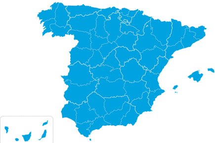
Regions of Spain
The regions of Spain are 17 administrative units. They are:
- Andalusia,
- Catalonia,
- Madrid Region,
- Valencia Region,
- Castile-La Mancha,
- Castile and León,
- Murcia,
- Extremadura,
- Asturias,
- Aragon,
- La Rioja,
- Cantabria,
- Galicia,
- Basque Country,
- Navarre,
- Canary Islands
- Balearic Islands.

Provinces of Spain
Spain is divided into 50 provinces, each of which has its own government and administration. In addition, provinces have the right to form voluntary associations, which are called autonomous communities. Currently, there are 17 autonomous communities, each of which has its own statute, as well as separate celebrations and holidays. All Spanish provinces, except Ceuta and Melilla, enjoy the right to form autonomous communities. Ceuta and Melilla are autonomous cities that are governed directly by the Spanish government.
Within the island provinces, there is an additional division into individual islands. This means that each island province consists of several smaller administrative units. In the case of mainland provinces, the subdivision into lower-level units (intermediate between municipality and province) is voluntary and not commonly used. They can be found under the name comarcas or mancomunidades de municipios. In some cases, a comarcas area may include municipalities that are part of different provinces.
It is worth noting that each municipality in Spain has its own mayor and municipal council. Municipalities are the lowest administrative unit in the country and can exercise the powers they are entitled to according to the state legislature and the constitution. Among other things, municipalities deal with land use, public health, culture, education and social welfare.

Cities of Spain
Below is an inventory of the largest cities in Spain, however, it should be noted that this is the current status and today’s data may differ slightly from those shown below.
Cities in Spain with more than 1million inhabitants

Cities in Spain with a population between 500,000 and 1,000,000 inhabitants

Cities in Spain with a population between 200,000 and 500,000 inhabitants

Cities in Spain with a population between 100,000 and 200,000 inhabitants


